
The Ideal Street Grid for Extraterrestrial Settlements — Project Pathway
An extraterrestrial settlement requires multiple structures in relatively close proximity. As such, the spaces in between the structures become de-facto streets, or pathways. As more and more structures are added, the space efficiencies between the structures becomes increasingly important for a fledgling settlement with limited resources.
Terrestrially speaking, there are really only two categories of pathway grids used: the organic grid and the rectilinear grid. The organic grid arises from impromptu settlement patterns without enforced oversight; buildings are constructed where the builder/owner desires and the pathways form around the buildings as water flows around boulders in a stream. Rectilinear grids on the other hand can only form where there is an authority enforcing compliance with master planning and parcel ownership.
For this analysis, I have chosen the the following grid types to compare: hexagonal grid (hex), square grid (square), and triangular grid (tri). These are the three main two-dimensional grid types formed by "blocks" of regular polygons. There are no other single polygon types that can tile two-dimensional space.
Prior to this analysis, I made two hypotheses:
grids with long, straight lines (square, tri) can be traversed more quickly
hex grids can pack more blocks into a smaller radius
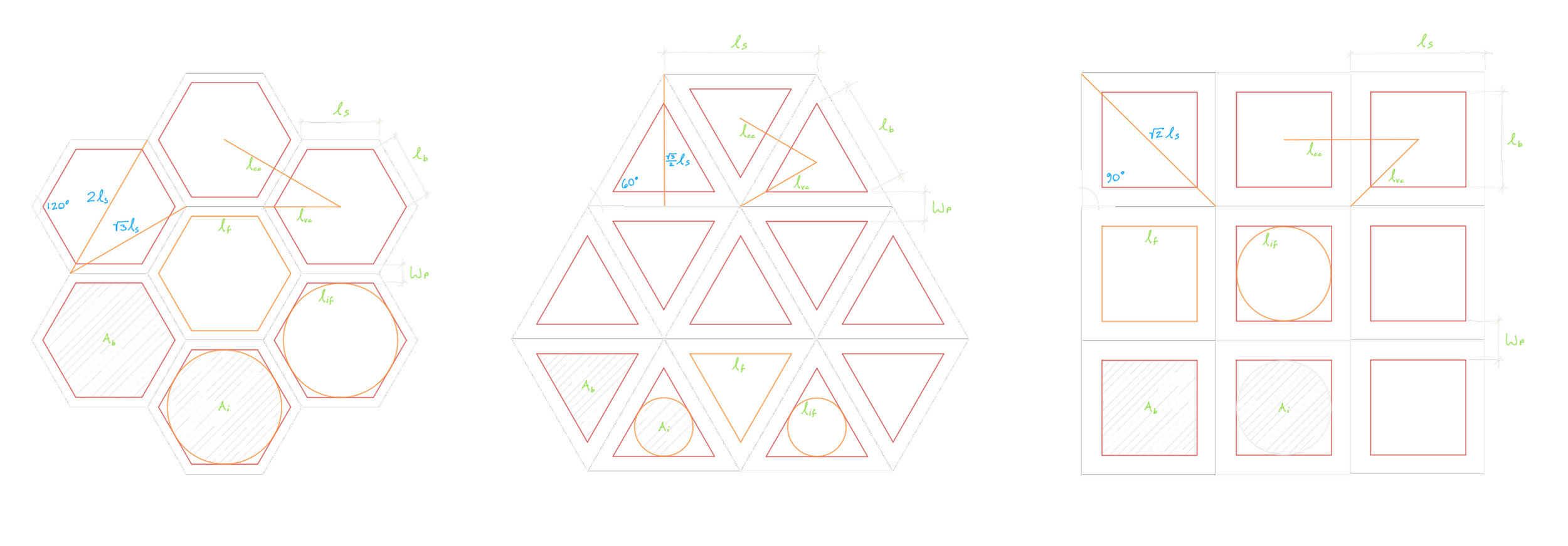
Anatomy of a Grid
Before I can introduce the analysis, I must first explain the terminology I will be using.
In its purest form, a grid is defined by the grid type (hex, square, or tri) and segment length (l_s). These two properties fix any grid in a notional two-dimensional space. From these fundamental attributes, the center to center distance (l_cc) and the vertex to center distance (l_vc) can be derived. The main attribute of a given pathway in a grid is the pathway width (w_p). The line tracing the center of the pathway is the same line representing the geometrically pure grid, as the pathway straddles the grid. From the pathway width and the segment length, the block length (l_b), the block area (A_b), and the inscribed block area (A_i) can be derived.
In the context of pathway grids, a grid is composed of two regions: the pathway (negative space) and the block (positive space). In a given survey radius (and by extension, survey area), the total area of all pathways and the total area of all blocks can be derived from the survey area (A_s), the pathway width, and a given proportion of pathway area (P_p), equal to the total area of pathways divided by the survey area). Of course, this can be worked in reverse as well, so that the proportion of pathway area can be derived from the survey area, the pathway width, and the total area of the pathway or the total area of the blocks.
Frontage is the notional perimeter of the blocks that is accessible from the outside. For the purposes of this analysis, I distinguish between block frontage (l_f) and inscribed frontage (l_{if}). The block frontage is simply the perimeter of the blocks within the survey area, while the inscribed frontage is the perimeter of the inscribed circles of the blocks within the survey area. The inscribed frontage may be a more useful metric than ordinary frontage, as the buildings constructed on extraterrestrial worlds may not be shaped like hexagons, squares, or triangles, and may instead be shaped like circles (given the likely pressure differential between the inside and outside of the habitats).
Traversing the pathways is an important aspect of any grid system meant for transportation. A representative network can be constructed from the grid type and the segment length. From this representative network, an analysis of the pathway efficiency can be conducted. I will refer to the results of this analysis as the network path analysis.
Metrics
The following metrics will be used to compare the candidate grid types.
Proportion of Pathway
All things being equal, it would be best to reduce the amount of negative space as much as practical. Because of this, space dedicated to pathways that can't otherwise be used for other functions is generally undesirable. For this reason, a smaller proportion of the pathway area is better than a larger one.
Total Length of Pathway
Pathways require valuable resources to build and maintain, and resources are rarely more valuable than they are on an extraterrestrial world. For this reason, the length of pathway built should be limited rather than extensive.
Total Length of Frontage
As frontage is defined as the amount of access to the blocks from the pathways, being able to access more of the blocks from the pathways is a boon (more frontage is better). It means there are more opportunities for immediate access to the block area without having to go deep into the blocks.
Total Length of Inscribed Frontage
On an extraterrestrial world, it is likely that the exterior pressure will be different from that of the insides of the habitat. For this reason, the structures that would be built are likely to have circular plans, as round shapes make more efficient pressure vessels. For this reason, the length of the circle circumference that can fit into a given block is a good measure of the size of structure that can fit into the block. Like the Total Length of Frontage metric, it is also a boon in this case to have more inscribed frontage.
Center to Center Distance
This metric generally measures how close two blocks are to each other, or otherwise how many blocks can fit into a given area. Having blocks closer together can be advantageous in that it reduces the distance that personnel, utilities, and materials have to travel if they were to be passed between structures.
Vertex to Center Distance
This metric generally measures the distance needed to travel from the central area of the blocks to the nearest pathway intersection. Like the previous metric, this distance should not be too large, as a longer distance increases the length of the average trip between block locations.
Network Path Analysis
For a given survey area, this metric results from a digitally constructed graph of all the intersections of the pathway for a given grid type of a certain segment length. Coordinate pairs within the survey area are chosen at random, and the shortest paths between these coordinate pairs through the graph are compared to a straight line between the coordinate pairs (a performance value. It should be obvious that the best performing candidate would have a distance that is closer to the straight line (more close to ideal).
Constants
For the purposes of this analysis, the following variables were kept constant, as they did not have meaningful bearing on the comparison between the grid types.
Survey Area
The survey area used for this exercise is the circular area created using a radius of 2,500 m. At full scale, this size is likely more than enough for a reliable comparison between the grid types.
Pathway Width
At full scale, the width of the path should be considered a practical matter. It should be large enough for easy navigation between structures, but small enough that the structures are reasonably close together. The model for determining this distance was based on the width between blocks in the narrow streets of Manhattan (60'). The pathway width was set to be 20m in all instances.
Controls
In order to compare the grid types fairly, the properties of the grids should control for a universal property, one that is shared among the grid types. For this exercise, the following controls were considered.†
Block Area
The first method considered for use as a control is the block area. Controlling for block area means that for each grid representation has the same block area. Since these block areas would be the same across the grid types, the results should meaningfully speak to how the grid types compare with each other. Combined with the constants (survey area and pathway width), each grid can be constructed in a determinate way, meaning that all the other measurements follow from just these three measurements.
Inscribed Area
Similar to the block area control, the inscribed area control is keeps an area the same across the grid types, but instead of block area it controls for the inscribed area. This control is meant to correct for the reality that structures are likely to be circular rather than fill the block shape. Just like the block area control, each grid can be constructed in a determinate way from just the inscribed area, the survey area, and the pathway width.
† Originally, an additional control of pathway proportion was considered. This would have controlled for the proportion of the survey area dedicated to pathway (as opposed to block area). However, it just so happened that this control results in the same exact grid layout as the inscribed area control, rendering it redundant.
Methodology
The relative importance between the grid type's effect on the various metrics is unknown and may depend heavily on the specifics of the extraterrestrial settlement implementation (which resources are scarce, how the structures are built and connected, etc). Due to this subjectivity, the method chosen to analyze the performance of the grid types was Multi-criteria Decision Analysis (MCDA), similar to that used in Project F12's Morphology paper (link).
For each of the grid types, the raw values were recorded for each of the metrics. Then these raw values were transformed into performance values by taking the absolute value of the difference between the raw value and that of baseline (ie: the worst-performing metric) according to the following equation:

Where P is the performance value, V is the raw value, and B is the baseline value.
These performance values were then normalized to a sum of 1 for each metric. These normalized values were the values used for the MCDA analysis.
For the MCDA analysis, an importance level upper limit was set to (8) levels. This means that every combination of importance factors for the set of (10) metrics for each of the (3) grid types were analyzed, resulting in 1,072,693,245 unique combinations. For each of the combinations, the importance factors were multiplied by the respective normalized values of each of the grid types, and the winner for that combination was the grid type that had the highest resultant value. These combination winners were then tallied and aggregated at the end of the analysis.
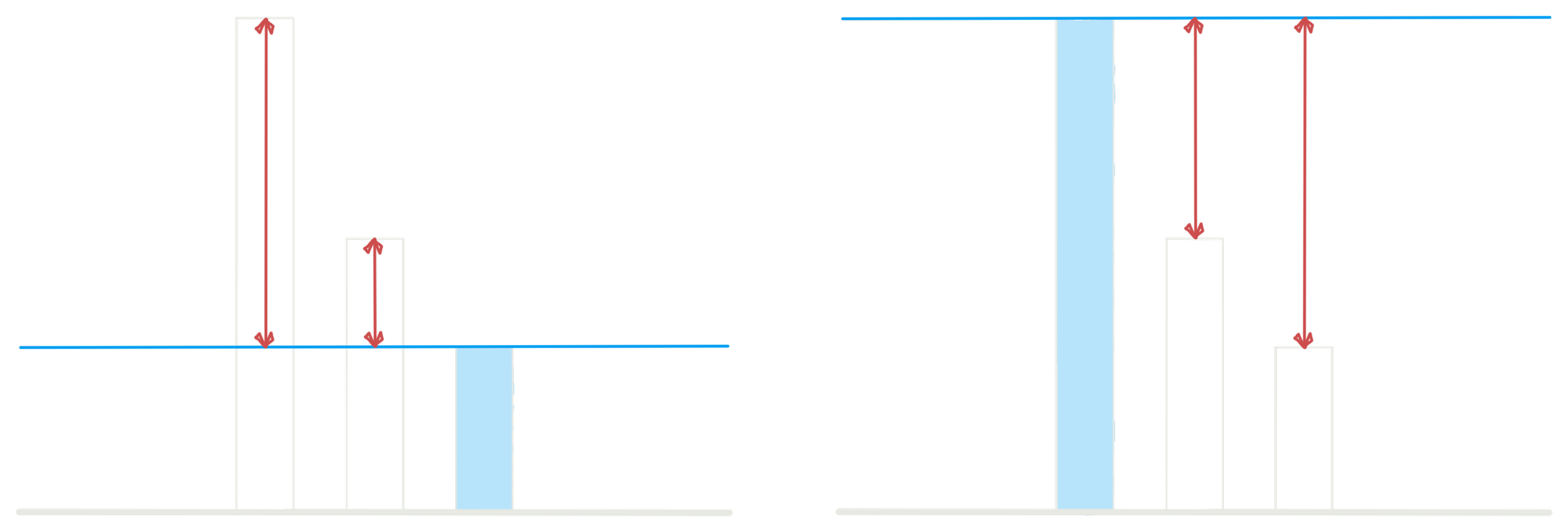
Graphics showing the performance values (red) for raw values in which the worst-performing metrics are low (left) or high (right).
Results
Over the 1,072,693,245 unique importance factor combinations, the analysis results showed that the hex grid was the best performing grid type for 78.6% of the combinations, the tri grid was the best for 21.4% of the combinations, and the square grid was the clear loser, winning 0.0% of the combinations.
The square grid in particular is dominated by the presence of both the hex grid and the tri grid; where the square grid outperforms the hex grid it does not outperform the tri grid, and where it outperforms the tri grid it does not outperform the hex grid. This makes the square grid a dominated category in a value-maxing MCDA.
These results suggest that the hex grid is the best performing grid type and should be the grid type assumed by default for any prospective extraterrestrial settlement design. While the square grid and tri grid are efficient for long, uninterrupted stretches of fast travel without turns, this is unlikely to be a dominating boon in an early extraterrestrial settlement. Rather, closeness and space/resource efficiency is likely to be more important in this case.